Day 45
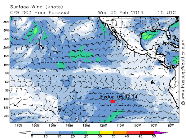
“My situation in the Pacific Ocean is intense. It’s exhausting to keep the boat turned into the wave, especially when the gigantic waves are trying to turn the boat sideways. They look like mountains raising high and then dizzyingly fast run under the boat. The wind is a non-wavering 20 knots, from the east. Hopefully, as the weather report forecasts, the wind should slow down to 15 knots to give me some relief. Yesterday the day was cloudy, not a glimpse of the sun. As soon as the main accumulators dropped to 80% voltage capacity, I switched to the reserve ones. But the night turned out to be fairly calm and clear, with stars and crescent moon. The morning looks promising; I hope it turns out to be a good day. It’s time to run the watermaker, for at least 15 minutes. Pumping fresh water is always an important event on board. To have a drinkable water supply is crucial to my survival; without it I won’t last long. As far as catching fish to press the juice out of it, I have had only one successful catch, and that was back in the coastal waters of Chile. I’ve got the best fishing gear and extensive experience fishing from my previous ocean adventures. I can’t figure out why I’m having such bad luck with fishing here. It could be that Tourgoyak is too slow for a productive trolling, or simply, there is no fish in this area of the Pacific. Either way, my predictions of catching fish to add to the menu, haven’t been realized.
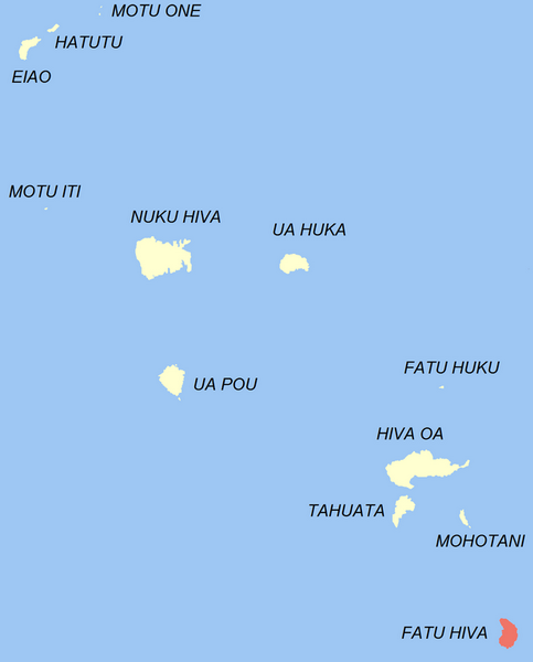
As far as navigation goes, I have decided to have Fatu Hiva as my main way point. It was exactly to Fatu Hiva that Thor Heyerdahl moved with his wife in 1937. He developed a theory that the ancient Polynesian people had arrived not from the Southeastern Asia, but from South America. He had famously proved his theory by crossing the Pacific from Peru to Polynesia on Kon-Tiki raft. I didn’t choose this island because of the Heyerdahl heritage there, but because it is simply the southernmost island of the Marquesas Islands. My plan is to pass Fatu Hiva at the starboard, and then begin descending to Australia, keeping the course at south-west. The island coordinates are 10°30′ S, 138°40′ W. The coordinates of Brisbane are 27°30′ S, not to mention that it’s in the Eastern Hemisphere of our planet. It’s so far away that I don’t even think about this location right now. However, Fatu Hiva is 1400 nautical miles away, and this distance is much more comprehendible and manageable. With God’s help, I’m hoping to approach the island by mid-March. It will be the first land since I left Concon in December.”
The map of the Tourgoyak’s course: http://yb.tl/konyukhov2
The detailed map of the course: www.oceanrowing.com/Konyukhov/Pacific2013/dist_map.htm
Translated by Tatiana Koreski